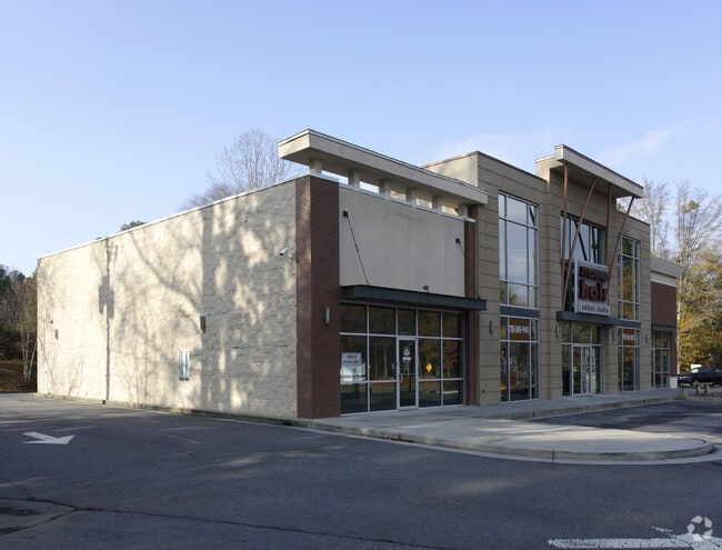
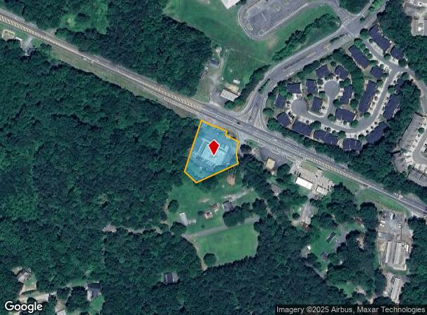
Property Record
7970 Knox Bridge Hwy, Canton, GA 30114


NEARBY LISTINGS FOR SALE OR LEASE
Property Detail
7970 Knox Bridge Hwy
14N12B-00000-006-000
LL 90; 14TH D
Commercialnec
Cherokee
X
Georgia
13057C0233E
90
2025
1 AC
2025
Cherokee/Woodstock
090301
Atlanta
7,519 SF
Atlanta-Sandy Springs-Roswell, GA
DEMOGRAPHICS near 7970 Knox Bridge Hwy
1 Mile
3 Mile
5 Mile
2024 Total Population
6,972
32,585
77,123
2029 Population
7,945
37,159
88,267
Pop Growth 2024-2029
+ 13.96%
+ 14.04%
+ 14.45%
Average Age
38
37
39
2024 Total Households
2,304
11,203
27,348
HH Growth 2024-2029
+ 14.11%
+ 14.20%
+ 14.65%
Median Household Inc
$111,328
$103,723
$89,155
Avg Household Size
3.00
2.80
2.70
2024 Avg HH Vehicles
2.00
2.00
2.00
Median Home Value
$359,737
$345,438
$355,526
Median Year Built
2004
2003
2001
Nearby Places
- Restaurants
- Banks
- Shops
- Fitness
- Groceries
Nearby Properties
Address
Land Use
TOTAL SIZE
Lot Size
Zoning
Address
Land Use
TOTAL SIZE
Lot Size
Zoning
255,483 SF
138.30 AC
LI
Address
Land Use
TOTAL SIZE
Lot Size
Zoning
443,973 SF
70.02 AC
GC
Address
Land Use
TOTAL SIZE
Lot Size
Zoning
353,395 SF
29.15 AC
GC
Address
Land Use
TOTAL SIZE
Lot Size
Zoning
79,162 SF
8.54 AC
RM16
Address
Land Use
TOTAL SIZE
Lot Size
Zoning
103,620 SF
19.78 AC
R-5
Address
Land Use
TOTAL SIZE
Lot Size
Zoning
302,757 SF
62.80 AC
PUD
Address
Land Use
TOTAL SIZE
Lot Size
Zoning
177,744 SF
23.73 AC
PUD
Address
Land Use
TOTAL SIZE
Lot Size
Zoning
155,341 SF
14.54 AC
R-5
Address
Land Use
TOTAL SIZE
Lot Size
Zoning
241,482 SF
31.65 AC
PD
Address
Land Use
TOTAL SIZE
Lot Size
Zoning
43,897 SF
8.45 AC
PUD
Address
Land Use
TOTAL SIZE
Lot Size
Zoning
62,308 SF
7.57 AC
ERC
Address
Land Use
TOTAL SIZE
Lot Size
Zoning
31,428 SF
10.21 AC
R-3
Address
Land Use
TOTAL SIZE
Lot Size
Zoning
138,048 SF
21.40 AC
R-40
Address
Land Use
TOTAL SIZE
Lot Size
Zoning
182,067 SF
23.83 AC
GC
Address
Land Use
TOTAL SIZE
Lot Size
Zoning
85,408 SF
37.56 AC
AG
Address
Land Use
TOTAL SIZE
Lot Size
Zoning
44,397 SF
15.84 AC
GC
Address
Land Use
TOTAL SIZE
Lot Size
Zoning
33,071 SF
1.70 AC
TND
Address
Land Use
TOTAL SIZE
Lot Size
Zoning
23,500 SF
3.50 AC
PD
Address
Land Use
TOTAL SIZE
Lot Size
Zoning
14,370 SF
0.34 AC
GC
Address
Land Use
TOTAL SIZE
Lot Size
Zoning
24,984 SF
2.16 AC
GC
Address
Land Use
TOTAL SIZE
Lot Size
Zoning
57,363 SF
19.68 AC
PUD
Address
Land Use
TOTAL SIZE
Lot Size
Zoning
78,503 SF
9.51 AC
PUD
Address
Land Use
TOTAL SIZE
Lot Size
Zoning
158,853 SF
33.73 AC
LI
Address
Land Use
TOTAL SIZE
Lot Size
Zoning
67,422 SF
8.14 AC
PUD
Address
Land Use
TOTAL SIZE
Lot Size
Zoning
56,484 SF
9.04 AC
GC
Address
Land Use
TOTAL SIZE
Lot Size
Zoning
56,991 SF
5.82 AC
NC
Address
Land Use
TOTAL SIZE
Lot Size
Zoning
114,112 SF
4.84 AC
RA-8
Address
Land Use
TOTAL SIZE
Lot Size
Zoning
41,010 SF
22.25 AC
PUD
Address
Land Use
TOTAL SIZE
Lot Size
Zoning
21,886 SF
4.06 AC
CBD
Address
Land Use
TOTAL SIZE
Lot Size
Zoning
12,743 SF
2.74 AC
CBD
The World's #1 Commercial Real Estate Marketplace
Connect with us
© 2025 CoStar Group
The information above has been obtained from sources believed reliable. While we do not doubt its accuracy we have not verified it and make no guarantee, warranty or representation about it. It is your responsibility to independently confirm its accuracy and completeness. Any projections, opinions, assumptions, or estimates used are for example only and do not represent the current or future performance of the property. The value of this transaction to you depends on tax and other factors which should be evaluated by your tax, financial, and legal advisors. You and your advisors should conduct a careful, independent investigation of the property to determine to your satisfaction the suitability of the property for your needs.